


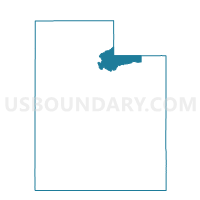
Oakley Voting District, Summit County, Utah
About
Outline

Summary
| Unique Area Identifier | 679971 |
| Name | Oakley Voting District |
| County | Summit County |
| State | Utah |
| Area (square miles) | 1,257.45 |
| Land Area (square miles) | 1,251.43 |
| Water Area (square miles) | 6.02 |
| % of Land Area | 99.52 |
| % of Water Area | 0.48 |
| Latitude of the Internal Point | 40.85237260 |
| Longtitude of the Internal Point | -110.65119740 |
Maps


Graphs
Select a template below for downloading or customizing gragh for Oakley Voting District, Summit County, Utah


Neighbors
Neighoring Voting District (by Name) Neighboring Voting District on the Map
- 2-1-2 Voting District, Uinta County, WY
- ALMY HILLIARD Voting District, Uinta County, WY
- Altamont Voting District, Duchesne County, UT
- Echo Voting District, Summit County, UT
- Hoytsville Voting District, Summit County, UT
- Kamas East Voting District, Summit County, UT
- Manila Voting District, Daggett County, UT
- Marion Voting District, Summit County, UT
- McKinnon Voting District, Sweetwater County, WY
- Mountain Home Voting District, Duchesne County, UT
- MT. VIEW OUTSIDE Voting District, Uinta County, WY
- Neola Voting District, Duchesne County, UT
- Peoa Voting District, Summit County, UT
- Tabiona Voting District, Duchesne County, UT
- Upton Voting District, Summit County, UT
- Wanship Voting District, Summit County, UT
- Wasatch County - North Voting District, Wasatch County, UT
- Woodland Voting District, Summit County, UT
- Woodruff Voting District, Rich County, UT
Top 10 Neighboring County Subdivision (by Population) Neighboring County Subdivision on the Map
- Evanston CCD, Uinta County, WY (14,613)
- Heber City East CCD, Wasatch County, UT (9,965)
- Kamas CCD, Summit County, UT (6,763)
- Bridger Valley CCD, Uinta County, WY (6,505)
- Coalville CCD, Summit County, UT (4,865)
- Green River South CCD, Sweetwater County, WY (3,709)
- Randolph-Woodruff CCD, Rich County, UT (1,038)
- West Daggett CCD, Daggett County, UT (886)
- Uintah and Ouray CCD, Wasatch County, UT (11)
- North Duchesne CCD, Duchesne County, UT (6)
Top 10 Neighboring Place (by Population) Neighboring Place on the Map
Top 10 Neighboring Unified School District (by Population) Neighboring Unified School District on the Map
- Wasatch School District, UT (23,530)
- Duchesne School District, UT (18,607)
- Uinta County School District 1, WY (14,618)
- Sweetwater County School District 2, WY (13,657)
- South Summit School District, UT (7,001)
- North Summit School District, UT (4,922)
- Uinta County School District 4, WY (3,252)
- Rich School District, UT (2,264)
- Daggett School District, UT (1,059)
Top 10 Neighboring State Legislative District Lower Chamber (by Population) Neighboring State Legislative District Lower Chamber on the Map
- State House District 54, UT (42,563)
- State House District 53, UT (37,757)
- State House District 18, WY (9,703)
- State House District 19, WY (8,191)
Top 10 Neighboring State Legislative District Upper Chamber (by Population) Neighboring State Legislative District Upper Chamber on the Map
- State Senate District 26, UT (101,392)
- State Senate District 19, UT (91,855)
- State Senate District 25, UT (89,262)
- State Senate District 14, WY (19,890)
- State Senate District 15, WY (16,793)
Top 10 Neighboring 111th Congressional District (by Population) Neighboring 111th Congressional District on the Map
- Congressional District 1, UT (906,660)
- Congressional District 2, UT (890,993)
- Congressional District (at Large), WY (563,626)
Top 10 Neighboring Census Tract (by Population) Neighboring Census Tract on the Map
- Census Tract 9405, Wasatch County, UT (8,614)
- Census Tract 9753, Uinta County, WY (7,761)
- Census Tract 9754, Uinta County, WY (6,852)
- Census Tract 9752, Uinta County, WY (6,505)
- Census Tract 9403, Duchesne County, UT (3,847)
- Census Tract 9707, Sweetwater County, WY (3,709)
- Census Tract 9642.01, Summit County, UT (3,605)
- Census Tract 9642.02, Summit County, UT (3,055)
- Census Tract 9641.02, Summit County, UT (2,813)
- Census Tract 9501, Rich County, UT (2,264)
Top 10 Neighboring 5-Digit ZIP Code Tabulation Area (by Population) Neighboring 5-Digit ZIP Code Tabulation Area on the Map
- 82930, UT (14,614)
- 84036, UT (6,045)
- 84017, UT (3,556)
- 84055, UT (1,406)
- 84046, UT (793)
- 84061, UT (391)
- 84031, UT (259)
- 82938, WY (227)
- 82944, WY (216)
- 82936, WY (49)